 Earth&Sun is a program for the PalmPilot to show the Sun Illuminated area of the Earth.
Because of time zone irregularities some will consider Earth&Sun to fall into the category of
"fun and games".
We hope you find Earth&Sun useful and enjoy it.
If you have Earth&Sun V1.1 installed, installation of this V1.2 will replace the V1.1.
If you have Earth&Sun V1.0 installed in your PalmPilot after installation of Earth&Sun V1.2 you will
have the older V1.0 still installed. Simply delete the V1.0. (The older Earth&Sun is titled "Earth&Sun",
the new version is titled "Earth & Sun", for your convenience).
Use the Pilot installer to install earth12.prc. Earth&Sun requires mathlib.prc*. If you already have mathlib.prc already installed just install earth12.prc. Otherwise install both earth12.prc and mathlib.prc.
Note: If your PalmPilot is using OS3.5 be aware that there is a bug in OS3.5 such that it will not remember the category of any re-installed application. Thus for both new or re-installation will have to move Earth&Sun out of 'unfiled'.
Using the Program
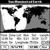
The map display should be obvious. The shaded area is that part of the world that is dark at the
current time. The location where the Sun is directly overhead is shown by a little icon which is a +
sign outlined in reverse 'color'. It is not too obvious in the screen shots shown here. You can find it
located over Ecuador.
Hopefully program usage is pretty much self evident once you have followed these instructions. Earth&Sun has two modes of operation: Time Mode, and Distance Mode. Initially it is in the Time Mode.
The "Done" button will set the value and return to the main screen.
RealTime Clock
In the 2X mode the sunrise/set times are accurate for the displayed latitude/longitude. See for
discussion on the Normal/Freeze Button which follows. This gives an example of different times
at different longitudes.
Normal/Freeze Button To use this feature, in the 2X and Normal mode, put the pen down on a location which is in the
desired time zone. For example: Alaska time is 9W, so tap the map on eastern Alaska and verify that
the time zone is 9W. Then observe the sunrise/set times. Next tap the (N) button. It will change to
(F) -- Freeze. Then tap the western part of Alaska and the sunrise/set time should be about 2 hours
later. Now tap the far western Aleutians Islands and see the sunrise/set advance another hour. Note
that the time zone still reads 9W.
With a frozen time zone it is possible that the sunset could occur in the next morning. In this
case the time might be, e.g. 24:10. The same is true for sunrise except it might occur the previous
night, with a sunrise e.g. of 23:45.
Note: In these cases the Date Selector does not change.
The Bray PalmPilot Page can be found at:
http://www.40-below.com/palm/
This archive may be freely redistributed, provided it is made available
only in its complete, unmodified form with no additional files and for
noncommercial purposes only. Any other use must have prior written
authorization from David W. Bray at bray@clarkson.edu.
Unauthorized commercial use includes, but is not limited to:
GMT Time Zone Offset is the number of hours the PalmPilot's local clocks differ from that
of Greenwich Observatory in England. Set the Time Zone menu to correspond to the following table
according to your location.
Upon first use you will be greeted with a message requesting you to tell Earth&Sun the time zone to
which the PalmPilot's clock is set. This is an offset from GMT (Greenwich Mean Time). If you do not
set this the display will always be incorrect!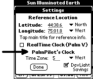 First just set the PalmPilot's Clock Time Zone and check DayLight Savings if applicable.
(See GMT offset time zone table if you do not know what to enter.)
Below is a discussion on the other two items in the Prefs.. menus. Ignore them at first.
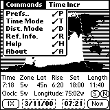
Time Mode
To understand the following instructions first tap the pen on an earth location.
Look at the first and second rows of the text output display area from left to
right.
For the tapped location:
Looking at the third row of the output display from left to right:
Looking at the forth row of the output display from left to right:
Hardware Scroll Buttons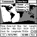
The Up/Down hardware scroll buttons in the lower center of the PalmPilot allow you to simulate
time changes in increments of: 1, 3 and 6 hours. Pressing the Up bottom advance time and the Down
button decreases time. You can change the time increment/decrement value using the Time Incr
menu. Wrapping time around for 24 hours does not change the date.
Distance Mode
You switch between the Time and Distance Modes with the Commands menu, or simply by tapping the word
"Time" ("Loc") on the first line below the map.
 In the Distance mode the text output display area changes as shown on the right.
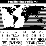
Tap a location on the map. For the tapped location:
Next tap the "2" button on the third line and it will become highlighted. Then
tapping the map will fill in the data for Loc 2 and change the distance to reflect the new location.
"Br:" is the great circle bearing from Loc 1 to Loc 2.

Prefs.. Menu and RealTime Clock
Reference Location
The Reference Location is for you to enter a location for which you would frequently like to find the
sunrise and sunset, your home for example, you may enter that location into the Reference Location of
the Prefs.. menu. Then when you tap to the right of "Sun Illuminated Earth" it will fill in the data
for that location. You may also tap the data line that shows time/rise/set, or use the 'Ref. Info.' menu
item. This works in either the Time or Distance modes.
If you do not enter a location the data will always be for the equator.
If you have a PalmPilot which is plugged into external power (such as Palm V or a computer Palm
simulator) you may use Earth&Sun as a real time clock. Simply check the "RealTime Clock (Palm V)"
checkbox.
When that box is checked and the PalmPilot is plugged into external power, the Time
Selector box will be in synchronism with the PalmPilot clock and the map will be updated every 5
minutes. Five minutes is the smallest time which can show a Sun shadow change. When the external
power is removed the updating will stop.
More Details
Sunrise/set Time Values
You will find that the sunrise and sunset times may be different in the 1X and 2X
modes. The reason is that the calculated values are for different longitudes in the two modes:
The reason for two different calculation is a matter of accuracy of pen positioning. On the 1X
display it is difficult to locate a particular latitude/longitude, so it was found that giving
the sunrise/set times for the center of the time zone would give more consistent results. This
means that the sunrise/set times are the same for all time zones at a given latitude! Thinking
about that for a moment you may conclude that it is a useful feature.
Since the time zone is based solely on longitude the Normal/Freeze button allows you to freeze a
time zone so that in the 2X mode you can find sunrise/set times for locations which do not
follow normal time zone rules. For example: Alaska which extends over 4 time zones, Russia and
China which extend over 3 times zones. Also there are locations like western Texas where the
time zone boundary is very much west of where it should be
Contact Info
Earth&Sun was created by David W. Bray, Potsdam, NY;
Copyright © David W. Bray 1998-99, All Rights Reserved.
The author may be contacted at: bray@clarkson.edu
Registering
Earth&Sun is freeware no registration is required. We hope you enjoy using it.
Disclaimer
This program is provided without warranty and the user accepts full responsibility for
any damages, consequential or otherwise, resulting from its use.
Foot Notes
* - Many thanks to Rick Huebner, the author of MathLib, for his excellent routines and
making them freely available.
Back to "Using the Program"
United States Around the World
Time Zones Offset Time Zones Offset
Eastern 5 West British Isles 0 East
Central 6 West Western Europe 1 East
Mountain 7 West Eastern Europe 2 East
Pacific 8 West So. Africa 2 East
Alaska 9 West Russia 3 East
Hawaii 10 West Japan 9 East
Eastern Australia 10 East
*Program Changes in Version 1.2
Earth&Sun Version 1.2 differs from earlier versions in: